Thursday was plagued by heat advisories across much of Florida. The entire peninsula, covering more than 50 counties, was under a Heat Advisory, meaning that between 11 a.m. and 7 p.m., temperatures would be dangerously high, with heat indices reaching as high as 111°F.
The culprit behind this extreme heat is a high-pressure system that brings sinking air over Florida. As the air sinks, it compresses and warms. Adding to the heat is abundant sunshine, as Saharan dust remains in place across much of the state, suppressing showers and thunderstorms that typically provide afternoon relief from the summer heat.



Across Florida, numerous temperature records could be broken or tied on Friday and Saturday. On Friday afternoon, record-high temperatures could be challenged from Gainesville through Florida's Gulf Coast, including Tampa, and extending south to Cape Coral. Punta Gorda could reach its record high of 97°F, set in 2024, while Tampa International Airport could tie its record high of 96°F, set in 1999.
On Saturday, additional record highs could be broken or tied across Central and Southwest Florida. Friday and Saturday mornings will also be exceptionally warm. Many locations across South Florida may not fall below 82°F overnight. In Miami, a low of 82°F would tie the record warm low set in 2007. The Florida Keys could also come close to tying the record warm low of 86°F, set in 2023. Overall, between Friday morning and Saturday morning, more than a dozen stations could tie or break record warm low temperatures.
“The temperature inside a vehicle can rise 20 degrees in as little as 10 minutes and 50 degrees in an hour, even when outside air temperatures are in the 70s.”National Weather Service
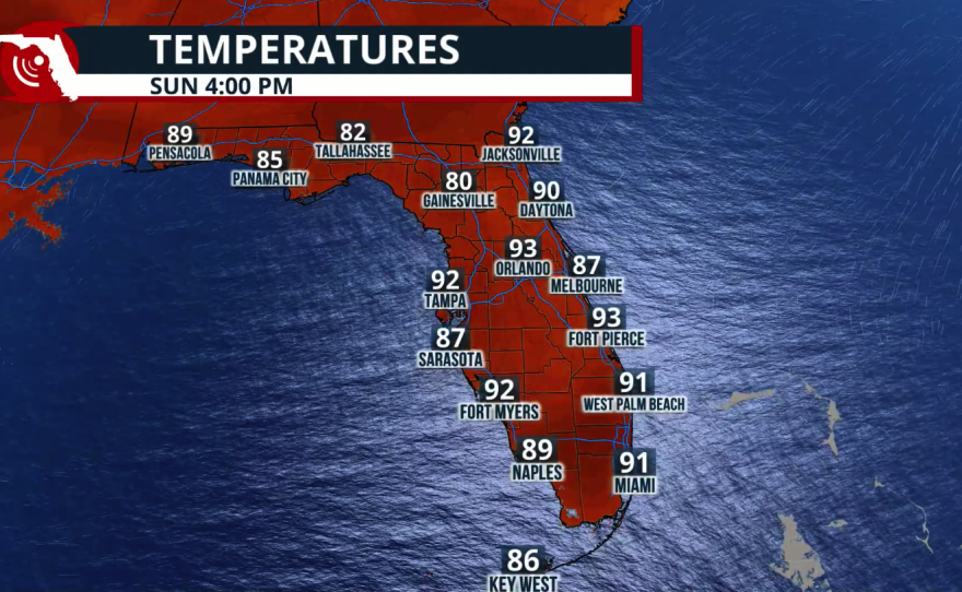
Don't let your guard down. Although Sunday is not expected to bring widespread record temperatures across Florida, the heat will remain intense. In fact, early next week the heat is expected to intensify across much of the state. South Florida, in particular, could once again approach record highs. In Miami, the record high of 95°F, set in 1976, is threatened by a forecast high of 94°F.
Florida will be dusty for days!
— Florida Public Radio Emergency Network (FPREN) (@FloridaStorms) July 9, 2026
This will prevent most of the shower and thunderstorm activity from becoming widespread, although brief pockets of opening could allow some isolated activity on Friday for South Florida and on Saturday for Central Florida. pic.twitter.com/dpb20OpTgX
Rain, dust, or both?
The weather will remain mostly dry across much of the peninsula on Friday. Although a few late-day showers could move into South Florida from the southeast, this pocket of moisture will have to compete with the large amount of Saharan dust still present in the atmosphere. Any thunderstorms that do develop will most likely form after 4 p.m. Some of these storms could also affect Southwest Florida.
By Saturday, we expect mostly sunny but still hazy conditions across South Florida, with an isolated thunderstorm that could move from Southwest Florida eastward toward Lake Okeechobee. Central Florida could also experience an isolated shower or thunderstorm during the late afternoon.
During the weekend, shower and thunderstorm activity will become more common across the Florida Panhandle, although the region is expected to remain mostly dry on Friday and Saturday. Rain chances will increase on Sunday as a frontal boundary approaches the southeastern United States and moves close enough to the Panhandle to trigger scattered showers and isolated thunderstorms.
Parts of Florida could see more showers than others over the next few days, but overall, activity is forecast to be lower due to a thick layer of Saharan Dust in place through the weekend. pic.twitter.com/rE0SEUujFh
— Florida Public Radio Emergency Network (FPREN) (@FloridaStorms) July 9, 2026
Tips to Stay Safe in the Heat
- Drink water frequently, even if you don't feel thirsty.
- Take breaks in the shade or in air-conditioned areas to cool down.
- Gradually increase workloads and allow more frequent breaks for new workers or those

Children Are More Sensitive to Heat.
Children's bodies heat up faster than adults', making them especially vulnerable to heat-related illnesses. If you're a parent or caregiver, follow these safety tips:
- Touch the child's car seat and seat belt before placing them in the vehicle to make sure they aren't too hot.
- Never leave a child unattended in a vehicle, even for a minute or with the windows cracked open.
- Teach children never to play in, on, or around vehicles. They could accidentally become trapped inside a hot car.
- Always lock your car doors and trunk, even when the vehicle is parked at home, and keep keys and key fobs out of children's reach.
- Before leaving your vehicle, always check the back seat to make sure every child has gotten out. Never leave a sleeping infant or child in a parked car.
Remember: The temperature inside a parked vehicle can rise rapidly, becoming deadly within minutes, even on days that don't feel extremely hot outside.

Heat Exhaustion vs. Heat Stroke
Both heat exhaustion and heat stroke are serious and should be taken seriously. Heat exhaustion can quickly progress to heat stroke, which is a life-threatening medical emergency.
Heat exhaustion symptoms may include:
- Heavy sweating
- Dizziness or lightheadedness
- Weakness or fatigue
- Nausea or vomiting
- Muscle cramps
- Cool, pale, or clammy skin
Heat stroke is much more dangerous. A person with heat stroke may:
- Have a body temperature of 104°F (40°C) or higher
- Have hot, red skin (which may be dry or still sweaty)
- Experience a severe headache
- Become confused, disoriented, or behave unusually
- Lose consciousness or have seizures
A common misconception is that people with heat stroke always sweat heavily. In fact, some people stop sweating altogether, while others may continue to sweat—especially if the heat stroke developed after strenuous physical activity. The key warning signs are a very high body temperature and changes in mental status.
If you suspect someone has heat stroke, call 911 immediately. While waiting for emergency responders, move the person to a cooler place and begin cooling them with cold water, ice packs, or wet towels if possible. Early treatment can save a life.