
It was a cold start to the week, particularly in parts of North and Central Florida. While the last cold front lingered across South Florida, it has slowly moved northward. We expect this front to finally dissipate as the next cold air mass departs the Great Lakes area and moves south.
Get ready for a strong cold front that will not only sweep away the rain and clouds Florida will have on Wednesday, but also bring the coldest temperatures of the season for much of the state on Friday. For some, it will be the coldest temps in 3 years! Stay tuned! pic.twitter.com/VxOdq2kRA2
— Florida Public Radio Emergency Network (FPREN) (@FloridaStorms) January 14, 2026
Arctic air is slowly making its way south and will arrive in Florida just in time to finish off the week. The cold front that is exiting the Great Lakes area will bring freezing temperatures across the Deep South. We expect not only frigid temperatures that could harm sensitive vegetation but also hazardous conditions for vulnerable populations, including children and the elderly.
Tuesday was a wet day across many cities in South Florida, with Key Biscayne receiving nearly 2.5 inches of rain in almost 24 hours and Hollywood receiving just over 1.5 inches in the same period.
We need the rain... but we'd like some sunshine, too. Tuesday's totals are working to battle against a moderate drought that has settled across metro South Florida. @nbc6 pic.twitter.com/07MhXpT5Ty
— Ryan Phillips - NBC6 (@RyanNBC6) January 14, 2026
On Wednesday, we will begin to notice that the pattern in place across much of the state is shifting. Florida will have partly to mostly cloudy skies with scattered showers across much of the state as the first front that crossed the state at the beginning of the week retracts and moves toward Central Florida, and the starts to fizzle out.
At the same time, we have an incoming wave moving from the west that will bring instability across the western portion of the Panhandle. There will be scattered showers across parts of Pensacola through Tallahassee, with a low chance of an isolated storm. The overall pattern across Florida will move from west to east.
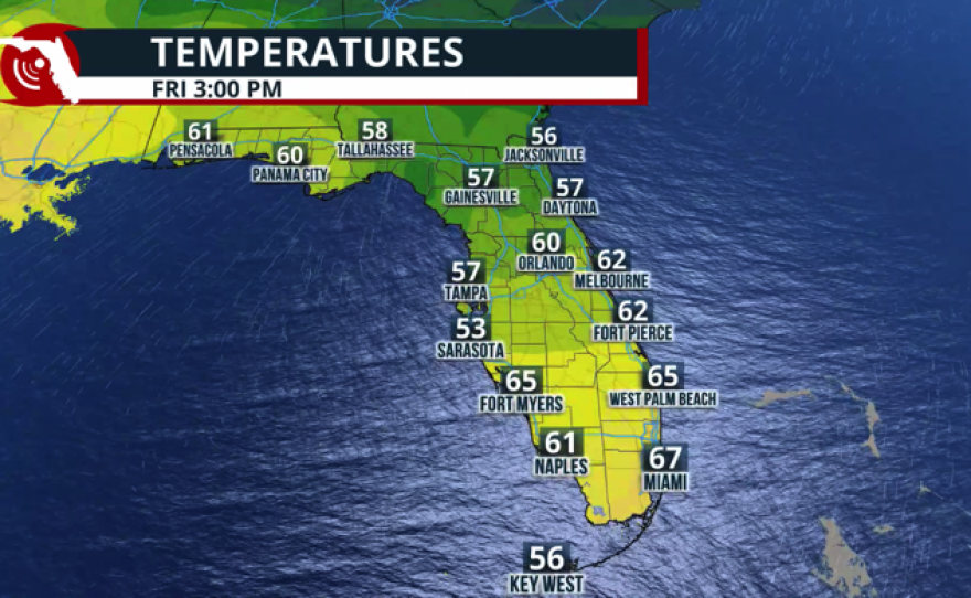
By Thursday morning, the cold front will be entering the Panhandle. The rain will be ahead of the front, likely crossing Central Florida by the afternoon, and by Thursday night, the cold front will be exiting South Florida. As the cold front pushes south on Thursday afternoon, expect the skies to gradually clear from north to south. As the skies clear, temperatures will drop quickly. If you’re located in the Panhandle, expect the temperatures to drop during the day on Thursday. Across South Florida, the temperatures could be around the mid-50s by 6 p.m. Thursday. In the Panhandle, temperatures will be in the mid- to upper 40s by then.
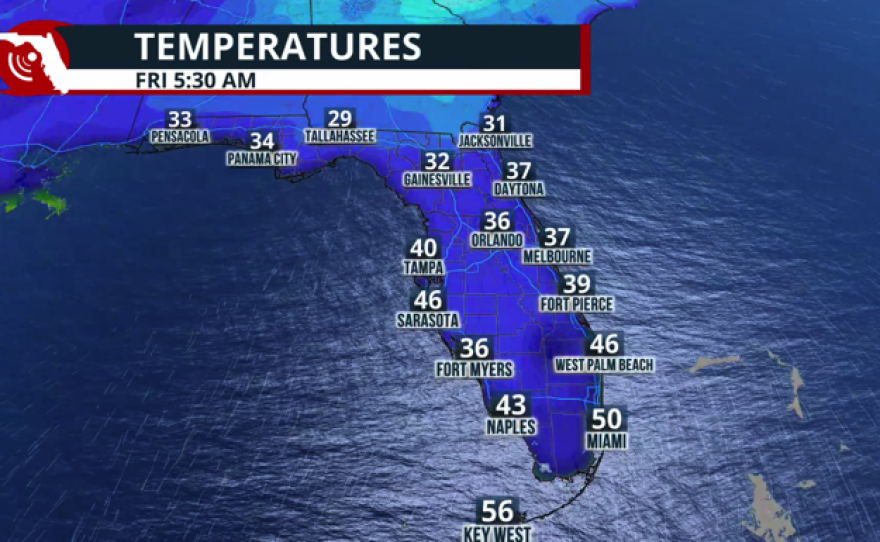
Once the sun sets, temperatures will continue to fall quickly, and we expect a very cold night across the Panhandle. Temperatures could fall to the upper teens, and the wind will likely make them feel 5 to 8 degrees lower. Thursday night into Friday, you need to bring the sensitive plants indoors and ensure that kids and the elderly are protected. Across Central Florida, temperatures will be around the low 30s by Friday morning. The wind will also be strong across this area, which could make temperatures feel in the upper 20s.

For South Florida, this could be the coldest air mass of the winter so far, and for places like South Florida, these could be the coldest temperatures in three years. Temperatures across southeast Florida are forecast to be close to 45°F by sunrise on Friday, while southwest Florida will likely wake up to temperatures in the upper 30s with strong northern winds that could make him feel as if they were between the low to mid 30s.

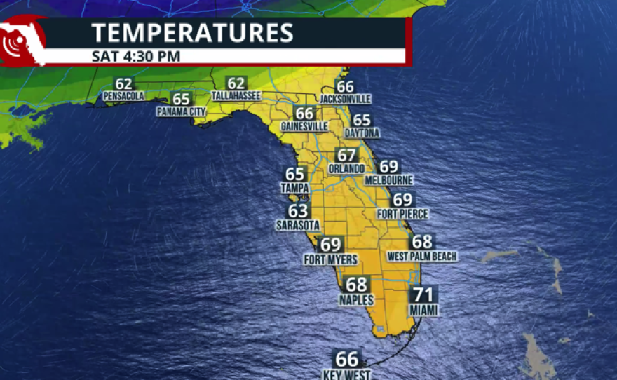
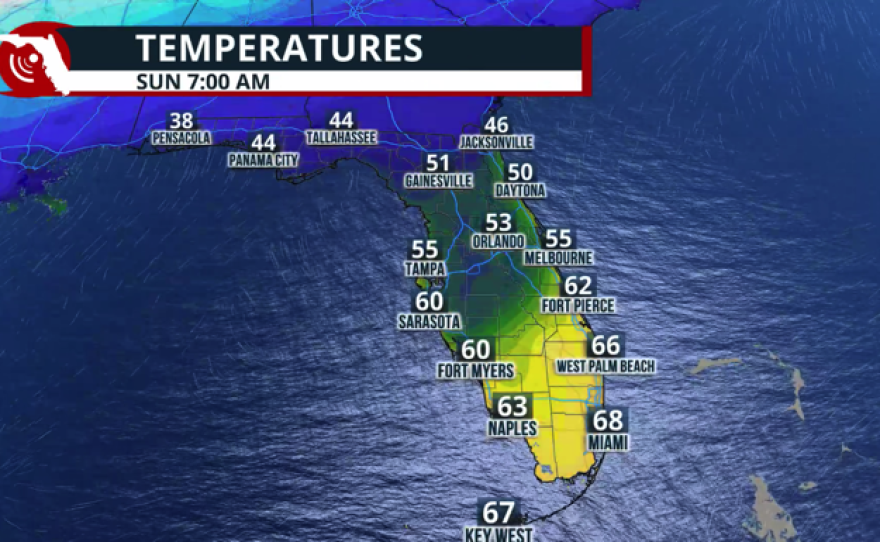
Although temperatures will moderate slightly, we still expect them to remain below average for this time of year statewide. We will continue to be under a high-pressure system that will gradually shift the winds and diminished them but the cooler air mass will stay in place keeping the temperatures on Saturday around the upper 60s to lower 70s across south Florida, Central Florida will stay with temperatures in the afternoon in the 60s while Saturday morning will be another cold one by Sunday morning temperatures will stay around the mid to upper 40s.
One more cold front to reinforce the cold air.
The better news is that the cold air will likely remain in place at the start of next week. Another cold front will push through the state on Sunday, reinforcing the cold across Florida and keeping temperatures in the colder range on Monday. We’re not expecting a colder air mass than the one that we’re going to have on Friday, but at least we will remain with temperatures that will be well below normal for this time of the year highs on Monday could be between 5 to 10° below average staying around the mid 60s across South Florida between the mid to upper 50s across Central Florida. North Florida and the Panhandle will wake up on Monday morning with temperatures in the upper 20s, and the sunshine will allow afternoon temperatures on Martin Luther King Day to reach the mid- to upper 50s.
