Resource Links | Important Numbers | Terms To Know | Storm News
It’s that time of year again. Florida’s hurricane season lasts from June 1 until November 30. If you’re new to the state or just in need of information on how to keep yourself and your loved ones safe, the Central Florida Public Media news team has compiled links to some of the most important information you’ll need.
Stay Safe this hurricane season and remember, Central Florida Public Media is here to keep you up-do-date with life and property saving information.
RESOURCE LINKS
CENTRAL FLORIDA COUNTY EMERGENCY INFORMATION, SHELTERS AND EVACUATION ZONES:
Brevard | Lake | Marion | Orange | Osceola | Polk | Seminole | Sumter | Volusia | Flagler
STATE/NATIONAL RESOURCES:
NOAA | Fla. Div. Of Emergency Management | FEMA
MORE RESOURCE LINKS:
Disaster Supply Kit Checklist
Flood maps
Know your Zone
Evacuation plan
Shelters
Preparing your homes
Medicine refills
Hurricane safety for people with dementia
Special Needs Registry
Planning for your pet
Horse owner hurricane preparation
Mental health help during a disaster
What to do if you lose power
Power outage map
Dangers after a hurricane
Cleanup after a hurricane
Food Safety
Generator safety
Where to find gas
Report price gouging
Mosquitoes after a storm
Encountering wildlife after a hurricane
Beekeeper preparedness
IMPORTANT NUMBERS
Emergency help: 911
SAIL Hotline: 1-800-342-3557
FEMA: 1-800-621-FEMA (3362)
Non Emergency Support Services: 211
TERMS TO KNOW
Language surrounding hurricanes and other storms can often be confusing. With that in mind, we’ve also compiled a list of terms and their definitions.
Tropical Cyclone: Low pressure system that forms over warm tropical waters.
Tropical Depression: A tropical cyclone with maximum sustained winds of 38 mph or less.
Tropical Storm: A tropical cyclone with maximum sustained winds of 39 to 73 mph.
Hurricane: A tropical cyclone with maximum sustained winds of 74 mph or higher.
Major hurricane: A tropical cyclone with maximum sustained winds of 111 mph or higher. These are category 3, 4 or 5 hurricanes.
Tropical storm warning: A tropical storm warning is issued when sustained winds of 39 to 73 mph are expected in an area within the next 36 hours.
Tropical storm watch: A tropical storm watch is issued when tropical storm conditions are possible within the next 48 hours.
Hurricane Warning: A hurricane warning is issued when sustained winds of 74 mph or greater are expected in an area within the next 36 hours.
Hurricane Watch: A hurricane watch is issued when hurricane force winds are possible in an area within the next 48 hours.
Eye: The center of the hurricane.
Eyewall: The band or ring of clouds that surrounds the eye of a hurricane.
Landfall: The moment the center of the hurricane reaches the coastline.
Outer bands: An outer ring of rainfall and thunderstorms that surrounds a hurricane. Usually this is the first part of the storm to make landfall.
Storm surge: A rise in sea level corresponding with a hurricane or other intense storm at sea.
Cone of uncertainty: A diagram showing the projected path of a tropical storm or hurricane over the next five days.
Spaghetti plot: A diagram showing multiple paths a tropical storm or hurricane could take based on different prediction models.
Hurricane names: Any tropical cyclone that becomes a tropical storm or hurricane gets a name. Here’s the list of this year’s names.
National Hurricane Center: The National Hurricane Center or NHC issues watches, warnings and advisories for tropical weather.
Hurricane season: The Atlantic hurricane season runs from June 1 through November 30. This is when tropical cyclones are most likely to form in the Atlantic.
The peak of hurricane season: September 10 is the peak of hurricane season. Most hurricanes form between mid-August and mid-October.
Saffir Simpson Hurricane Wind Scale (ranking): The scale ranks a hurricane’s potential to do property damage based on its maximum sustained wind speeds. Hurricanes can be category 1, 2, 3, 4, or 5 storms.
Latest Storm News
-
 Disney World is no stranger to more extreme weather events. The warmest month is typically July with the most rainfall occurring in June.
 -
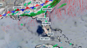
 A storm system moving across the eastern United States is expected to bring some parts of Florida their best chance of rainfall in about a month.
 -
 A cold front will try to get close to the I-10 corridor, while the strong east flow will keep the best thunderstorm chance along the western half of the Peninsula.
 -
 The series of historic freezes last month delivered one of the most damaging blows to Florida agriculture in decades. Meteorologist Leslie Hudson explains how the cold spread through the state’s crops — and why the impacts could ripple far beyond the fields.
 -
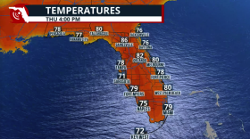
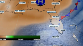
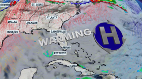 Highs will flirt with 90 degrees in some areas of Florida as a high-pressure system brings warm, humid air streaming from the south.
 -
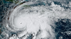 The World Meteorological Organization has retired the name Melissa from its Atlantic basin naming lists after the Category 5 devastated Jamaica in 2025.
 -
 Dry, breezy weather is helping to enhance pollen readings across the state with oak, juniper, pine and grasses being the top allergens.
 -
 NOAA forecasters believe the current La Niña state will transition into an ENSO-neutral pattern. Meteorological spring runs from March 1 through May 31.
 -
 Constant eastward wind flow will keep humidity levels present across parts of Florida. This also increases the risk of rip currents along Florida's east coast.
 -
 A rare celestial event will light up the skies on March 3 — the last total “Blood Moon” visible in the Americas until late 2028. Find out what makes this eclipse unique and when to look up before the moonset cuts the show short.
 -
 The weekend arrives with much-needed rain across Florida. It won’t be enough to alleviate the drought, but we’ll take anything we can get. Don’t expect a drop in temperatures, as the front will be weak.
 -
 When temperatures drop, so does your tire pressure. Digital meteorologist Leslie Hudson explains the simple science behind winter’s impact on your tires — and why ignoring that dashboard warning could cost you.


