Resource Links | Important Numbers | Terms To Know | Storm News
It’s that time of year again. Florida’s hurricane season lasts from June 1 until November 30. If you’re new to the state or just in need of information on how to keep yourself and your loved ones safe, the Central Florida Public Media news team has compiled links to some of the most important information you’ll need.
Stay Safe this hurricane season and remember, Central Florida Public Media is here to keep you up-do-date with life and property saving information.
RESOURCE LINKS
CENTRAL FLORIDA COUNTY EMERGENCY INFORMATION, SHELTERS AND EVACUATION ZONES:
Brevard | Lake | Marion | Orange | Osceola | Polk | Seminole | Sumter | Volusia | Flagler
STATE/NATIONAL RESOURCES:
NOAA | Fla. Div. Of Emergency Management | FEMA
MORE RESOURCE LINKS:
Disaster Supply Kit Checklist
Flood maps
Know your Zone
Evacuation plan
Shelters
Preparing your homes
Medicine refills
Hurricane safety for people with dementia
Special Needs Registry
Planning for your pet
Horse owner hurricane preparation
Mental health help during a disaster
What to do if you lose power
Power outage map
Dangers after a hurricane
Cleanup after a hurricane
Food Safety
Generator safety
Where to find gas
Report price gouging
Mosquitoes after a storm
Encountering wildlife after a hurricane
Beekeeper preparedness
IMPORTANT NUMBERS
Emergency help: 911
SAIL Hotline: 1-800-342-3557
FEMA: 1-800-621-FEMA (3362)
Non Emergency Support Services: 211
TERMS TO KNOW
Language surrounding hurricanes and other storms can often be confusing. With that in mind, we’ve also compiled a list of terms and their definitions.
Tropical Cyclone: Low pressure system that forms over warm tropical waters.
Tropical Depression: A tropical cyclone with maximum sustained winds of 38 mph or less.
Tropical Storm: A tropical cyclone with maximum sustained winds of 39 to 73 mph.
Hurricane: A tropical cyclone with maximum sustained winds of 74 mph or higher.
Major hurricane: A tropical cyclone with maximum sustained winds of 111 mph or higher. These are category 3, 4 or 5 hurricanes.
Tropical storm warning: A tropical storm warning is issued when sustained winds of 39 to 73 mph are expected in an area within the next 36 hours.
Tropical storm watch: A tropical storm watch is issued when tropical storm conditions are possible within the next 48 hours.
Hurricane Warning: A hurricane warning is issued when sustained winds of 74 mph or greater are expected in an area within the next 36 hours.
Hurricane Watch: A hurricane watch is issued when hurricane force winds are possible in an area within the next 48 hours.
Eye: The center of the hurricane.
Eyewall: The band or ring of clouds that surrounds the eye of a hurricane.
Landfall: The moment the center of the hurricane reaches the coastline.
Outer bands: An outer ring of rainfall and thunderstorms that surrounds a hurricane. Usually this is the first part of the storm to make landfall.
Storm surge: A rise in sea level corresponding with a hurricane or other intense storm at sea.
Cone of uncertainty: A diagram showing the projected path of a tropical storm or hurricane over the next five days.
Spaghetti plot: A diagram showing multiple paths a tropical storm or hurricane could take based on different prediction models.
Hurricane names: Any tropical cyclone that becomes a tropical storm or hurricane gets a name. Here’s the list of this year’s names.
National Hurricane Center: The National Hurricane Center or NHC issues watches, warnings and advisories for tropical weather.
Hurricane season: The Atlantic hurricane season runs from June 1 through November 30. This is when tropical cyclones are most likely to form in the Atlantic.
The peak of hurricane season: September 10 is the peak of hurricane season. Most hurricanes form between mid-August and mid-October.
Saffir Simpson Hurricane Wind Scale (ranking): The scale ranks a hurricane’s potential to do property damage based on its maximum sustained wind speeds. Hurricanes can be category 1, 2, 3, 4, or 5 storms.
Latest Storm News
-
 On Thursday, temperatures were already hot across much of the Florida Peninsula, with roughly two-thirds of the state under a Heat Advisory. Not only were air temperatures high, but the combination of heat and humidity pushed heat index values as high as 110°F in some locations.
 -
 Tropical storm Arthur was short lived, lasting only about 6 hours. But forecasters are watching for increased flooding rain and storm chances across parts of Florida later this week.
 -
 Arthur became the first named system of the season, but in less than 6 hours after being named, it moved over land in Texas. The flash flood threat continues for the next couple of days across the Southeast.
 -
 Heavy rains threaten the Gulf Coast states, from Southeast Texas through the Deep South. Heavy rains could affect parts of the western Florida Panhandle.
 -
 Florida is known for its sunshine and heat, but the state’s hottest air temperature is actually lower than nearly every other state.
 -
 A lower-category storm can still be deadly, and the kind of danger a hurricane brings often depends on which part of the state is in its path.
 -
 Dangerous heat is coming to North Florida and the Panhandle this weekend; the heat risk moves south next week.
 -
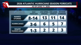 Colorado State lowers its 2026 Hurricane Season forecast due to a strong El Niño developing during the season. What does this mean?
 -
 Since reliable global temperature records began in the 1950s, Earth's warmest years have occurred during El Niño events, while the coolest years have typically coincided with La Niña conditions.
 -
 Record amounts of sargassum seaweed are washing onto beaches from Florida to Texas creating foul odors, frustrated beachgoers, and threatening coastal economies across multiple states.
 -
 A magnitude 6.1 earthquake off the coast of Cuba was felt across Florida on Monday afternoon, with residents reporting shaking in Miami, Tampa and Orlando.
 -
 Low rain chances for most of Florida & temperatures could feel like the triple digits across many areas this weekend. Read your forecast here.


